Landscape scenery
Is It Possible to ÔÇťCalculateÔÇŁ the Visual Landscape?
Susanne Hempp
GIS-based analysis of the visual landscape for the region ÔÇťUckermark - BarnimÔÇŁ as a base for the designation of areas suitable for wind generated energy
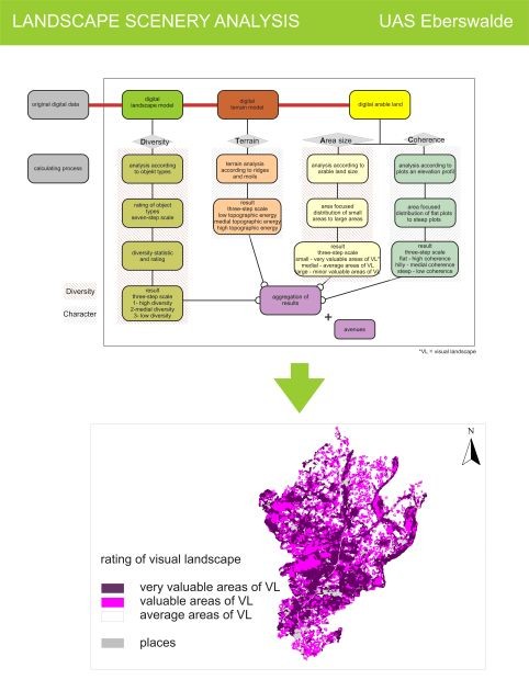
The identification of areas valuable for the visual landscape plays an important role for the characterisation of cultural landscapes. The study evaluates the visual appearance of the landscape on the base of digital data for the model region ÔÇťUckermark-BarnimÔÇŁ, initated by the research project ÔÇťArea Requirements and Cultural Effects of Regenerative EnergiesÔÇŁ. The classification and aggregation of the data in an automated GIS algorithm has led to a threestage ordinal scale of very valuable, valuable and average areas of visual landscape, verfied by in-situ checks.
The GIS-supported evaluation brought acceptable results. The methods works particularly well for areas with a high-value visual landscape. For other regions, however, the methodology has to be adjusted in order to comply with the regional particuliarities. Generally the automated GIS-supported evaluation should be verified and supplemented ÔÇťmanuallyÔÇŁ in order to better consider regional peculiarities.
Method of landscape scenery Analysis
Publication (only in German):
Peters, J., Torkler, F., Hempp, S., Hauswirth, M.: Ist das Landschaftsbild ÔÇťberechenbarÔÇŁ? / Is it possible to ÔÇťcalculateÔÇŁ the Visual Landscape?
In: Naturschutz und Landschaftsplanung ÔÇô Zeitschrift f├╝r angewandte ├ľkologie. 1/2009, 41. Jg. Verlag Eugen Ulmer. Stuttgart. S. 15-20.


